


Gachrash Forest is situated on the southern slopes of the Greater Caucasus Mountains in Quba District, approximately 25–30 km from Quba city, on the road leading toward Griz and Khinalig. The forest spans an elevation range of approximately 1,200 to 1,700 meters above sea level.

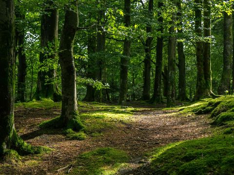
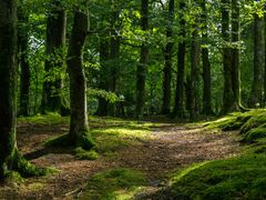
Gachrash forest, Guba, Azerbaijan
History & Origins

Although Gachrash is primarily known as a natural forest rather than a historical settlement, its location on the ancient mountain route between Quba and the highland villages suggests that the area has been traversed for centuries. Historically, this region was part of the Khinalig pastoral migration system, where shepherds moved livestock from lowland winter pastures to highland summer meadows.
The forest’s name appears in regional descriptive records in Azerbaijani and Russian sources from the late 19th to mid-20th centuries, often noted for its thick fog and rugged terrain. Soviet-era forestry documents describe the area as a valuable beech-dominated ecosystem essential for soil protection and water regulation in the Gudialchay basin.
Local oral tradition preserves the forest as a place of “white air” because of its heavy mountain fogs. Folklore among highland villagers references Gachrash as a landscape where hunters sought mountain goats and where shepherds found shelter under dense tree canopies during storms.
Geography & Climate
Geographic Highlights
- Located in the Gudialchay River basin
- Characterized by steep slopes, deep ravines, and thick woodland
- Surrounded by mountain meadows and highland pastures
- Often covered in year-round fog, especially in spring and autumn
- Experiences cooler temperatures compared to Quba and Baku
Climate
Gachrash lies within the moderately cold montane climate zone. It is known for:
- Frequent mist and low clouds, giving it a mystical atmosphere
- Summers that are cool and refreshing
- Winters that are cold, with snow covering the forest and roads
- High humidity levels due to cloud condensation
Seasonal colors are dramatic:
- Spring brings bright green foliage
- Summer provides deep shade and comfortable temperatures
- Autumn features red-gold forest colors
- Winter transforms the forest into a snow-covered, silent landscape
Ecology & Biodiversity
Gachrash is considered one of the most ecologically valuable forest zones of the Quba region.
Flora
The forest is dominated by:
- Oriental beech (Fagus orientalis)
- Hornbeam
- Oak
- Maple
- Birch
The dense canopy provides habitat for various understory plants, mountain flowers, lichens, and ferns. In wet seasons, mushrooms appear across the forest floor.
Fauna
Wildlife includes:
- Roe deer
- Foxes
- Hares
- Badgers
- Wild boar
- Numerous bird species, including mountain thrushes and woodpeckers
The forest plays an important role in soil erosion control and water regulation, especially for communities downstream along the Gudialchay River.
Environmental studies of the Greater Caucasus highlight the vulnerability of such montane forests to climate change, noting potential shifts in humidity and increased risk of landslides or deforestation if human impact is not regulated.
Cultural & Practical Importance
Although uninhabited, Gachrash Forest has long been culturally significant to local mountain communities.
Cultural & Traditional Relevance
- It served as a resting zone for herders moving toward highland pastures.
- Villagers used the forest for gathering natural herbs, mushrooms, and firewood.
- The forest is associated with local tales of hunters, shepherds, and travelers navigating through fog.
Modern Usage
Today, Gachrash is a popular:
- Picnic destination
- Outdoor recreation zone
- Scenic stop for travelers en route to Khinalig, Griz, and Afurdja Waterfall
- Photography and drone filming spot thanks to its dramatic mist
The forest also serves as a natural buffer, preserving mountain ecosystems and acting as an essential lung of the region.
Things to Do in Gachrash Forest
Hiking & Nature Walks
Several informal routes pass through the forest, offering easy to moderate hikes with scenic viewpoints.
Photography
The fog, tall beech trees, and broken light patterns through the canopy make the area one of the most photographed forests in Azerbaijan.
Picnics
Travelers often stop to enjoy meals in designated areas near the roadside.
Visiting Nearby Attractions
Its location makes it a perfect stop before or after:
- Gudialchay Canyon
- Afurdja Waterfall
- Griz Village
- Khinalig Village
Relaxation & Fresh Air
Gachrash is valued for its clean mountain air, serenity, and refreshing environment compared to urban areas.
Visitor Information
Location
Guba District, between Quba city and the villages of Griz and Khinalig.
How to Reach
- Private car: Road is accessible year-round, though winter may require caution.
- Taxi/Driver service: Common from Quba city.
- Old City Tours: Included in Quba–Khinalig and Gudialchay Canyon tours.
Entrance Fee
There is no entrance fee for Gachrash Forest.
Best Time to Visit
- April–October for comfortable hikes
- November–March for snow landscapes
- Autumn is particularly photogenic
Visit Duration
Typically 20–40 minutes, longer for hikes or picnics.
Facilities
- Roadside picnic areas
- Small teahouses depending on season
- No formal visitor center
- No restrooms beyond seasonal cafés
Nearby Attractions
FAQ
Is Gachrash Forest safe for families?
Yes, it is family-friendly with mild roadside areas suitable for short walks and picnics.
Do I need hiking experience?
No. Most visitors simply explore the forest edge. Light hiking paths are optional.
Is it always foggy?
Fog is common, especially in spring and autumn, but not constant.
Can I visit Gachrash in winter?
Yes, but snow can make the road slippery. A 4×4 may be advisable in heavy snow.
Are there restaurants?
Small teahouses or seasonal eateries appear in warmer months.
How long does a visit take?
Plan for around 2 to 3 hours at the volcano site itself. If combined with other attractions (e.g., Gobustan rock art) it may become a half-day or full-day outing.
Conclusion
Gachrash Forest is one of Quba’s most atmospheric natural landmarks—a place where mist, mountains, and ancient beech trees create a serene landscape unique to the northern Caucasus. Whether part of a cultural journey to Khinalig or an adventure into Gudialchay Canyon, the forest offers a refreshing break and a perfect setting for photography, fresh air, and peaceful nature.
To discover Gachrash Forest and the best of Quba with comfort, local expertise, and professional guidance, explore the Quba tours offered by Old City Tours.